


[DESIGN TEAMS]

Laser Scanning and Point Cloud Development for Engineering and Design Teams

Brownfield design starts from drawings that describe the plant as it was built, not as it stands today. DynamicJT delivers a registered point cloud in your format, with a registration report and a coverage map showing what was captured and what was not. Your team models and designs; we deliver field data it can build on. Projects start at a $5,000 minimum, quotes go out within 48 hours, and the proposal states the field date and the delivery date up front.

[WHAT YOU RECEIVE]

What you receive

Registered point cloud
•  All scan positions registered into one dataset.
•  E57 (ASTM E2807) as the vendor-neutral format, RCP for Autodesk workflows, LAS.
•  Leica LGSX project files, viewable in the free Leica TruView viewer.
Registration report
•  Registration method and quality metrics per project.
•  Lets your team judge the dataset before modeling on it.
•  Delivered with every project.
Coverage map
•  Shows what was captured and what was not.
•  Occluded areas, restricted access and areas above reach are marked.
Survey control
•  Local coordinates by default.
•  Tie to published datums through a licensed surveyor when the project requires it.
Deviation report
•  Available on request.
•  Compares a model to the point cloud.
Drawings and models
•  Scan-to-CAD/BIM and 2D line extraction into DWG are scoped separately.
•  Your design team keeps the design.
[ACCURACY]

How the instrument is chosen

Terrestrial scanners

Leica RTC360 and FARO Focus support tight-tolerance documentation. The RTC360 is manufacturer-rated under 1/8 in at 33 ft (1σ).

Mobile scanners

NavVis VLX 2 and Leica BLK2GO cover large areas in less field time, constrained to survey control to hold absolute accuracy.

Selected to your tolerance

The project tolerance is agreed at scoping, before mobilization, and documented in the registration report.

1σ is not project tolerance

Manufacturer figures are 1σ. We do not quote them as the tolerance your project will hold.

USIBD Level of Accuracy

If your specification references USIBD Level of Accuracy, we agree the target level before the first scan.

Safe and non-intrusive

Eye-safe lasers, quiet operation, minimal disruption to production.
[DELIVERABLES]

Typical deliverables

arrow rightarrow right
REQUEST A QUOTE
Registered point cloud (E57, RCP, LAS, Leica LGSX); LGSX opens in the free Leica TruView viewer
Registration report with registration method and quality metrics, delivered with every project
Coverage map showing what was captured and what was not
Deviation report, available on request, comparing a model to the point cloud
Scan-to-CAD/BIM scoped separately, including 2D line extraction into DWG
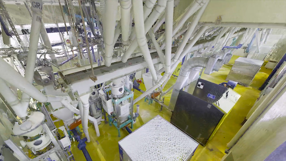
Point cloud of packaging-plant equipment captured with a 3D laser scanner
[USE CASES]

Common use cases for design teams

Brownfield retrofits and plant re-configurations
Piping design and tie-in checks in congested pipe racks
Equipment fit-up before fabrication and installation
Clash checks against existing conditions before construction documents are released
Shutdown planning with reduced on-site time
Plant documentation for engineering teams that model in-house
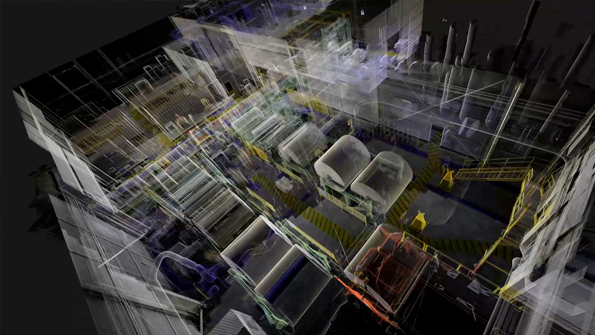
3D point cloud of a packaging plant production line from laser scanning
[HOUSTON-AREA WORK]

Recent work in the Houston area

Chemical plant, Greater Houston
One day on site, about 100 scan setups and roughly 20,000 sq ft of terrestrial scanning caught a steel design conflict before fabrication.
Read the case study
Valero Houston Refinery
We do this kind of work at refineries like the Valero Houston Refinery: plant documentation that lets engineers plan work from accurate 3D data.
Read the oil and gas guide
[FAQ]

Questions design and engineering teams ask

Answers on formats, accuracy, scope and fees for teams that design from the data.
Need drawings instead of data? See scan-to-CAD/BIM
get in touch
What are the fee and turnaround?
arrow up
Projects start at a $5,000 minimum and are scoped by field days and station count. Field capture is usually one mobilization and the registered point cloud follows within days. A quote goes out within 48 hours of a short scope call, with the field date and delivery date written into the proposal.
How is accuracy specified and documented?
arrow up
By instrument class and project requirement. Terrestrial scanners hold the tightest tolerance; mobile scanners are held to survey control. The target is agreed before mobilization and documented in the registration report. Manufacturer figures are 1σ and are not quoted as project tolerance.


Do you model the point cloud?
arrow up
Not as part of this package. Many design teams model in-house, so the standard scope stops at the registered dataset. If you prefer to receive drawings or a model, scan-to-CAD and scan-to-BIM are scoped separately and your team stays in control of the design. We do not produce design, engineering drawings or P&IDs.
Can you scan in an operating plant?
arrow up
In most cases, yes. Scanning is non-contact and quiet, so units typically stay in service. We plan capture around your access windows, escorts
and site safety requirements, and we confirm any prequalification requirements at scoping.
What does a point cloud development package include, and in which formats?
arrow up
•  Point clouds (E57, RCP, LAS and Leica LGSX, which opens in the free Leica TruView viewer)
•  Registration report with registration method and quality metrics
•  Coverage map showing what was and was not captured
•  Deviation report, available on request
Is this a land survey?
arrow up
No. It documents existing conditions for design and is not a boundary, easement, plat or ALTA/NSPS survey. When coordinates must be certified, we tie the scan to a licensed surveyor's control.
Where is our data processed?
arrow up
Tell us at scoping if you have requirements on processing location or subcontracted processing (U.S.-only, NDA, controlled data). Each proposal states where your project is registered and modeled, and we sign NDAs.
[GET IN TOUCH]

Send us the scope

Project address and site type, area or number of units, formats and software versions, access windows and your deadline. We reply with a fee and turnaround within 48 hours.
info@dynamicjt.com
+1 (832) 746-1497
1120 NASA Parkway, Suite 220D Houston, TX. 77058
Houston-Based Field Team
Point cloud flythrough animation of a scanned industrial building
Thank you! Your submission has been received!
Oops! Something went wrong while submitting the form.