


[EXISTING CONDITIONS]

Existing Conditions & As-Built Surveys by 3D Laser Scanning

When the drawings on file don't match the building or the plant, design starts on assumptions. An existing conditions survey gives your team field-verified dimensions — walls, doors, ceiling heights, columns, pipe, equipment and MEP — captured by 3D laser scanning and delivered as a registered point cloud, 2D as-built drawings in DWG or a Revit model. We document industrial and commercial facilities from Houston across Texas, Louisiana and Oklahoma, before you finalize construction documents.

[SCOPE OF SERVICE]

What does an existing conditions survey include?

Field-Verified Dimensions
•  Walls, doors, ceiling heights, columns and openings, captured in one mobilization.
•  Pipe, equipment, structure and MEP in industrial areas.
•  Above-ceiling areas when access is available.
Registered Point Cloud
•  Individual scans registered into a single colorized point cloud.
•  Navigable 360° panoramas for remote site walks.
•  Delivered in .E57, .RCP/.RCS or .LAS.
2D As-Built Drawings
•  Floor plans, reflected ceiling plans, sections and elevations in DWG.
•  Drafted from the point cloud, not from tape measurements.
3D As-Built Models
•  Revit or AutoCAD/Plant 3D models at the LOD your team specifies.
•  Model tolerance agreed to scope and documented in the deliverable.
Survey Control & Tolerance
•  Tripod-based or mobile capture, selected to the tolerance your project requires.
•  Mobile data tied to survey control when absolute accuracy matters.
Records for the Next Project
•  A point cloud your team can reuse for future renovations and capital projects.
•  One dataset shared by design, construction and facility teams.
[BENEFITS]

Why survey existing conditions before design?

See Pricing
COST GUIDE

Design on real conditions

Your team designs against measured geometry, not drawings that are decades out of date.

Fewer RFIs and change orders

Conflicts with existing walls, structure and MEP show up in design, not in the field.

One mobilization

Capture everything in one site visit instead of repeat trips with a tape measure.

Complete coverage

Full 3D capture of the space, not only the dimensions someone thought to measure.

Minimal disruption

Occupied offices and operating plants stay in service; scanning is quiet and non-contact.

Clear tolerance

Fraction-of-an-inch point clouds, with the instrument matched to the tolerance you specify.
[DELIVERABLES]

Typical deliverables

arrow rightarrow right
REQUEST A QUOTE
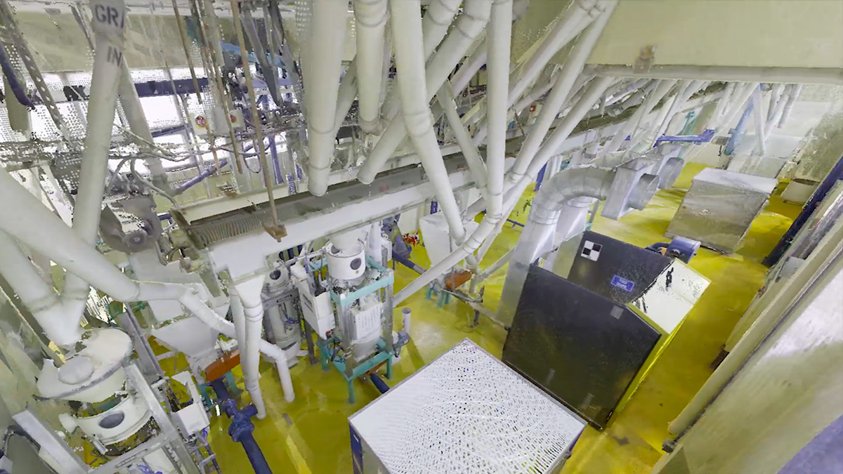
Registered point cloud (.RCP/.RCS, .E57, .LAS) with 360° panoramas
As-built 2D CAD (floor plans, reflected ceiling plans, sections, elevations)
Scan-to-BIM models (Revit/IFC) for structural, MEP, and architectural — coordinated through our modeling partners
Deviation/fit-up reports, available on request, for dimensional control and QA/QC
Point cloud archive for future renovations, retrofits, and operations
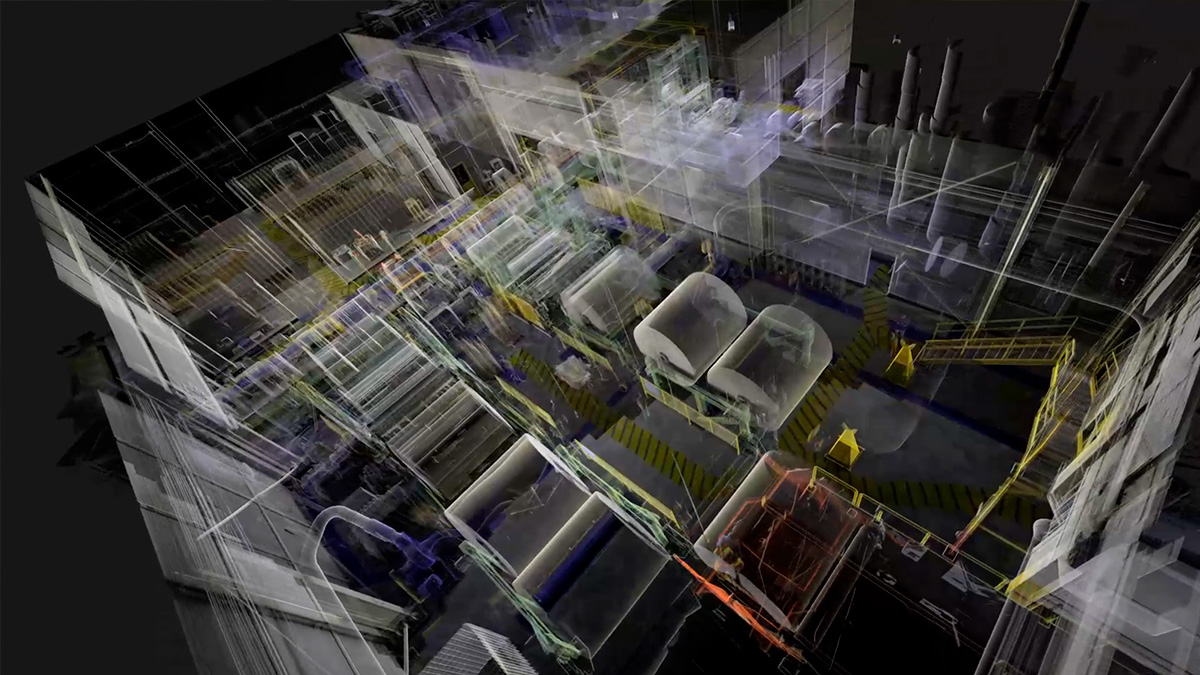
Point cloud of packaging-plant equipment captured with a 3D laser scanner
[USE CASES]

Who orders an existing conditions survey?

Design firms preparing construction documents for a tenant improvement
EPC and piping teams documenting brownfield tie-ins and revamps
Owners and facility managers replacing missing or outdated as-builts
General contractors validating existing conditions before bid and buyout
Architects documenting renovations, additions and adaptive reuse before permitting
Engineering firms — tunnels and infrastructure: centerline, FFE, utilities and points of penetration
3D point cloud of a packaging plant production line from laser scanning
[about SERVICE]

Frequently
Asked Questions

Answers to the questions design, procurement and facility teams ask before ordering an existing conditions survey.
get in touch
Is an existing conditions survey the same as a land survey?
arrow up
No. An existing conditions survey documents the building or facility as it stands today — dimensions, structure, MEP and equipment — for design. It is not a boundary or land survey. If your project needs coordinates certified by a licensed land surveyor (RPLS), that work is coordinated separately and the scan is tied to their survey control.
What does an existing conditions survey capture?
arrow up
•  Walls, doors, windows and openings
•  Ceiling heights, and above-ceiling areas when accessible
•  Columns, beams and structural members
•  Ductwork, pipe, conduit and electrical equipment
•  Floor elevations and slopes
•  Process equipment, pipe racks and tie-in points
•  Exterior elevations and roof equipment when in scope
How accurate is an existing conditions survey?
arrow up
Tripod-based scanners such as the Leica RTC360 are manufacturer-rated under 1/8 in at 33 ft; mobile (SLAM) capture typically runs about 1/4 to 3/4 in, tightened with survey control. Model tolerance is agreed to scope before mobilization and documented in the deliverable.
How long does an existing conditions survey take?
arrow up
Field capture is usually one mobilization; a tripod-based crew typically covers 15,000–30,000 sq ft per day in open areas. The registered point cloud follows within days, and 2D drawings take roughly two days of drafting per field day
; 3D models take about five.
What deliverables do I receive?
arrow up
•  Point clouds (E57, RCP, LAS, etc.)
•  2D drawings (plans, sections, elevations)
•  3D CAD or BIM models (Revit, AutoCAD, IFC, etc.)
•  Deviation reports, available on request, comparing construction vs. design
Do I need special software to view the scans?
arrow up
No. We can provide files compatible with free viewers (Autodesk ReCap, CloudCompare, etc.), so you don’t need expensive software to review your project.
Can you survey an occupied building or an operating plant?
arrow up
Yes. Scanning is non-contact and quiet, so offices, clinics and operating units typically stay in service. We plan capture around your access windows and site safety requirements.
Why order a survey instead of using the drawings on file?
arrow up
•  Reduces costly change orders
•  Prevents design clashes before construction
•  Eliminates repeat site visits
•  Gives design, construction and the owner the same baseline
What does an existing conditions survey cost?
arrow up
Most projects run $0.25–$0.50 per square foot for a registered point cloud, with a $5,000 minimum project; 2D drawings and 3D models are priced separately. Our 3D laser scanning cost guide breaks down scenarios — or request a quote with your square footage, site type and deliverable.
Is laser scanning safe?
arrow up
Yes. Terrestrial scanners use eye-safe, Class 1 lasers, making the process completely safe for people and equipment.
[GET IN TOUCH]

Let's Scope Your Existing Conditions Survey

Send your square footage, site type and the deliverable you need — we'll confirm the fee, turnaround and what's included.
info@dynamicjt.com
+1 (832) 746-1497
1120 NASA Parkway, Suite 220D Houston, TX. 77058
Houston-Based Field Team
Point cloud flythrough animation of a scanned industrial building
Thank you! Your submission has been received!
Oops! Something went wrong while submitting the form.